As part of an ongoing series, Ray Nayler blogs about life in Central Asia.
Every Wednesday and Friday in Tajikistan, weather permitting, the Aga Khan foundation flies a helicopter from Dushanbe to the remote city of Khorog, in the Pamir mountains at an elevation of 2200 meters (7,200 feet) above sea level. If space allows, and you happen to work for an NGO here in Tajikistan, and have some business in the autonomous region of Gorno-Badakshan, you can sometimes get a ride. Gorno-Badakshan is the home of the Pamiri peoples, Ismail Muslims whose native languages are a series of obscure Eastern Iranian offshoots with fewer that 100,00 native speakers, Anya and I were lucky enough last Friday to benefit from the Aga Khan’s largesse, and hitched a ride on the helicopter to Khorog, where we planned to conduct recruiting for one of our programs as well as a re-entry seminar for our FLEX alumni, high school students freshly returned from the United States, in this remote corner of Tajikistan.
To use the phrase hitched a ride makes it sound as if it was easy, but there were, as always in Tajikistan, a number of bureaucratic hurdles to jump through, from getting permission for entry to the Gorno-Badakshan Autonomous Region to getting space on the helicopter itself. But all of the bureaucratic hassles melt away as the sleek Bell lifts from the Dushanbe runway and the ragged patchwork of agriculture at the edges of the capitol, the rusty bones of industry and scrapyards, give way to crenellated hills and wide, drying river beds with ribbons of water veining through them, reflecting the sun like mirrored glass. The helicopter banks gracefully southeast as the passengers, ears muffled in protective headphones against the engines’ roar, settle in to some of the most spectacular scenery the world has to offer.
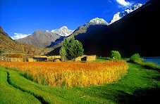
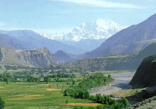
As we move further from the capitol, the mountains grow drier, more violently twisted from the flatlands below, and more imposing. Knife-ridges of rock lay exposed to the eroding wind, and layers of sediment hardened to granite lay tilted to the sky by tectonics. From far off, it appears as if the loose earth is running down the mountains like water. Soon we are flying not over but through the mountains, with grey sentinels rising around us and white flashes of snow that grow, over time, to glaciers grinding their way down the mountainsides and, as we hover over Afghanistan, sawblade ridges of stone outside our windows. Below, the Pyandzh River winds its course, and villages nestle up to, splashes and streaks of cultivated green in the arid, twisting scene.
On the Tajik side of the border, the houses are soviet-style, of concrete or sometimes mud-brick, their pitched roves clad in corrugated tin or fiberglass. On the Afghan side, the mudbrick homes are more chaotically aligned, their rooves flat, and they cling to the mountainsides more closely, reserving the scarce flatland for little amoeba-shaped fields fed by canals from the mountain rivers. On a trip by car to Bamyan from Kabul a few years ago I got a closer view of these canals, which provide a lifeline to the little mountain communities along the arid river valleys. The canals angle less steeply from the riverbed, along the base of the mountain. The Pyandzh River valley, above which we are now flying, receives less that 8 inches of water in a year. It is snowmelt which feds the river. Below the line of the canal, everything is green. Above it, there is no vegetation at all. The helicopter makes a steep turn over the Pyandzh River and comes gently to rest on the cracked tarmac of the Khorog airport.
“Welcome to Khorog.” A man with a nametag around his neck and several gold teeth whisks away our passports and permissions with a grin. Just four hours later, our small mission in this remote city smothered in poplar trees finished, we lift off again, crossing the flowing border between the two countries in the air, and follow the river back toward home. Some journeys really are about the trip, rather than the destination.
Subscribe to:
Post Comments (Atom)
Awesome and rugged

Beauty of Chitral
Kishmanja, a beautiful village in Yarkhun valley
Lush green
DIZG: threatened by floods
The legendary village of Ayun in Chitral

On way to Bumburet
Dizg, Yarkhun
About Me

- Zar Alam Khan Razakhel
- Village Dizg, Yarkhun valley, Chitral, Pakistan
- I blog at http://chitraltoday.net (ChitralToday) about Chitral, its people, culture, traditions and issues. I have been writing about Chitral since 2000. Chitral is a scenic valley in the extreme north-west of Pakistan.
No comments:
Post a Comment